US Route 12, from Lewiston, Idaho to Missoula, Montana, provides endless possibilities to get on the water year round. Whether you prefer to kayak, SUP or raft, you’ll no doubt find some fun on this stretch of easily accessible river.
Start near Lewiston, Idaho. Located in the Lewis-Clark Valley, Lewiston is typically warmer than neighboring communities and rarely gets snow. This is good for standup paddling if you’ve got the gear—ahem, drysuit—to accommodate colder temperatures in the winter and early spring. My favorite spot to do a jaunt on the SUP is from Chief Looking Glass Park (Asotin, WA) to Swallows Park (Lewiston, ID). A paved walking path between the two parks allows for an easy bike shuttle if you’re low on cars. Drop your gear and companions at Chief Looking Glass Park. Drive downriver to Swallows Park to leave the car and jump on your bike for an easy four-mile riverside ride back to Asotin. Enjoy a leisurely ‘urbanesque’ paddle downriver—read: paddling with the current—back to Swallows Park where there’s plenty of space and shade to have a picnic, slackline, or flick a frisbee.

For a more intense pedal-to-paddle trip, park the shuttle rig at Granite Lake Park or Red Rooster—a perfect spot for an après paddle beer or cocktail. Bike the Greenbelt Trail to Swallows Park (seven miles), and continue on to Chief Looking Glass Park for a total of 11 bike-miles. Hop on your SUP and double your time on the water, passing under the Blue Bridge (US 12), where the Snake and the Clearwater Rivers converge. This is also a great stretch for kayakers looking for calm waters. Don’t forget to pick up your bikes and then hit 12 heading east.
Once you leave Lewiston, a number of food options drastically drop, as in mostly nonexistent. Fill your bellies at Effie Burger a local hole-in-the-wall burger joint with burgers the size of a dinner plate. Order one burger with the works, a basket of curly fries and split it all four ways. The atmosphere is low-key and super casual—a small town tavern with a couple of old TVs, low lights and vintage booths—it’s worth a stop for a beer and enough hamburger meat to hold you over for six to eight hours. If Mexican makes your mouth water, Taco Cecy, a food-cart-sized restaurant with a patio for spillover, just blocks from Effie Burger serves authentic Mexican cuisine made from fresh local ingredients. This roadside taquerias may not have the abundance per plate as Effie, but for the same amount of money spent, you can fill your belly with enough tacos to last the afternoon.

Heading east out of Lewiston, there are convenient spots to leave a car for takeout at milepost 21 and 24 (depending on how far you want to paddle) for easy roadside SUP’ing. The put-in is going to be at milepost 28 at Lenore Rest Area. There are (real) restrooms, picnic tables, and vending machines here, but most importantly, river access. After dropping a car at your takeout, get your rig to the beach area and unload. Right at the put in, there’s a small wave train to play on (small depending on the river levels and your level of experience), with an easy eddy to catch if you aren’t as successful on your first try or want to run laps. The rest of the stretch is mellow, however there are a few shallow spots, so be aware not to catch your fins on the rocks.
By the time you reach Kooskia, you’re getting into kayaking turf, and for the best flow levels, plan your trip on US 12 for mid to late spring. The Lochsa, Clearwater and Selway Rivers are all free-flowing rivers fed by snowpack runoff. The water is cold this time of year and a drysuit is highly recommended, but a thick wetsuit (4-mil +) will work as well.

From US 12, go south on Highway 13 until the highway splits. Take Highway 14 about 14 miles to check out the Mickey Mouse section on the South Fork Clearwater for some Class IV paddling. The put-in is at an unnamed campground just below milepost 14 and you’ll take out near the merge of Highways 13 and 14. If you want Class V, continue 10 miles farther on 14 to the Golden Canyon stretch. It’s all roadside accessible, easily scouted, with plenty of pullouts to comfortably pick your way through this stretch.
Back on US 12, be sure to stop in Kamiah at Harvest Foods to gas up, grab some roadies (for camp, of course) and cold, deep-fried chicken. This is your last opportunity to stock up and use your phone. Cell service, including 3G, 4G, and all other internet services, ceases shortly beyond this point, so check in with your loved ones and/or brag about the fun you’re going to have before going off grid.

Fried chicken in hand, you’ll arrive at to the confluence of the Selway, Clearwater and Lochsa Rivers. This is the gateway to the Selway Bitterroot National Forest. Turn right onto Selway Road, making note of the flow on the gauge below the bridge, and continue east 20 miles along the river to Selway Falls. You won’t paddle the Falls (seriously, don’t), but it’s amazing to see, especially in the spring—when it really roars. Put in your kayak or raft anywhere below the falls for a picturesque Class II float back to the confluence. Several camping spots exist along the Selway—both public and private beaches—and a couple of group camps can accommodate several large groups if you can snag them before other campers post up.

Beyond the confluence, you’re enveloped in the beauty of the mighty Lochsa. The Lochsa follows the highway so you can scout each rapid on your drive to the put in. Leave a car downriver so you have a vehicle at the takeout—either at Knife’s Edge Campground or Split Creek Bridge. You have a couple of options for your put in, depending on what kind of day you want to have. The GOAT (Greatest of All Time) Range will get you 12 miles of paddling, the day trip is 22 miles, and the Dirty Thirty is—you guessed it—30 miles.
For the GOAT Range, put in at Fish Creek (milepost 121), which can’t be missed. It’s the most popular put in on the Lochsa. There’s a fairly new wooden boat ramp, restrooms, an emergency call box, and plenty of space to leave vehicles, rig rafts, and get stoked for boating. From House Wave to Split Creek, the Lochsa drops 85 feet per mile, compared to the rest of the river, which drops 40 feet per mile, making this the most popular stretch of the Lochsa. If Fish Creek landing is busy and you’re a kayaker up for a challenge, take Fish Creek Road one mile up for Class IV/V, busy, bumpy—not for beginners—rapids.


At milepost 124, you’ve reached Wilderness Gateway Campground, with ample camping and river access. During the busy season, be sure to check in with volunteers to camp or use the facilities. There’s a fee box for overnighters. If you aren’t staying the night, respect the paying campers, and consider donating to the fee box. Don’t be a dirtbag.
Farther up US 12 is Dead Mule Flats (milepost 127) or County Corner (milepost 129), where you’ll put in for the day trip stretch. I recommend not you putting in here if the river is above six feet; it can get really nasty.
If you’re going big and plan on the Dirty Thirty, put in at milepost 139. This stretch is not for the faint of heart, and completing this stretch in one day is a feat. Go with boaters that are familiar with this portion of the river to stay safe and get a lay of the land (water) before you do this with your own group.

If you’re a newb or don’t have your own raft, book a trip with one of five outfitters in the area. Mammoth River Adventures, Three Rivers, Lewis & Clark Adventures, Zoo Town Surfers, and ROW Adventures are all available to accommodate any experience levels or group sizes looking to have a good time with minimal preparation and planning for the guests.
Notable stops along the highway:
Pipeline (milepost 113) is a popular spot for surfing. There are almost always cars pulled over with someone surfing the wave, whether in a kayak or on a board. Lochsa Falls (milepost 114) is another fun scout on your way east. People often hang out at this pullout to watch the carnage and enjoy the view.

If hot springs are more your style, I suggest Weir Springs at milepost 143. The springs are three-quarters of a mile into the woods. They aren’t hard to find, just follow the well-beaten path. Although, if you’re hiking back in the winter, be very cautious as the terrain can get slick and icy. In the past, I would have recommended Jerry Johnson’s hot springs, but it got blown out this year so you might not want to make the trek.
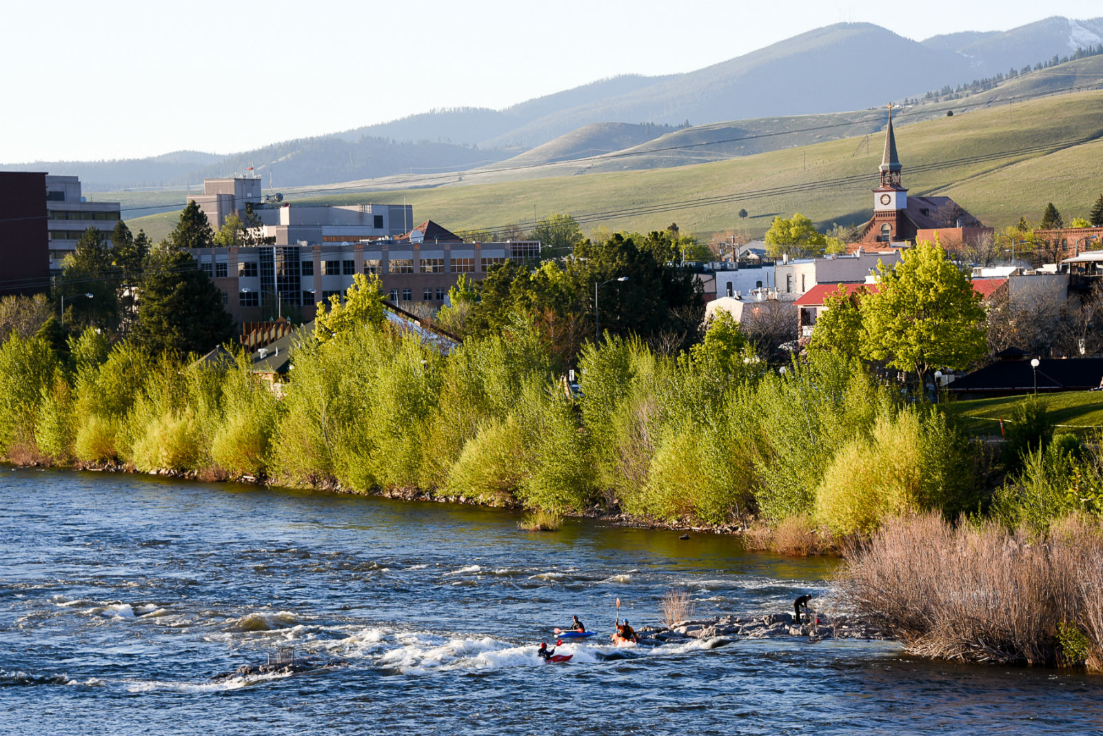
Finally, about two hours up the road, you’ll end up in Missoula, Montana—home of Brennan’s Wave. This fun little play wave is in the middle of town, accessible to anyone, and a great place to learn how to surf. You can walk across the bridge, watch people surf (successfully or not), and go test out the wave yourself. Afterward, be sure to give the local breweries a try. With more than seven to choose from, you’re guaranteed to find a new favorite or at least one that will do the trick.
With over 200 miles of winding roads and river access, a trip down US 12 from Lewiston, Idaho to Missoula, Montana is not one to miss. Whether you have a week, a weekend, or just want to plan a quick overnighter, there is flatwater and whitewater to be had and gorgeous wilderness area to be seen on this one stretch of blacktop.
Editor’s Note: Guest contributor, Austin Wassmuth is the co-owner of Mammoth River Adventures, a guide for Mountain River Outfitters and all-around good dude who occasionally rocks a mullet.